The Southern Townships of Lennox and Addington County
The Original Township
of Fredericksburgh
“Third Town of
Cataraqui”
Boundaries
were surveyed by November 1783 but the lot lines were
not run until the following year
Settled
in 1784 by the KRR NY, Butler’s Rangers and Jessup’s Rangers under Major James
Rogers.
Named for Prince August Frederick, Duke of
Sussex, ninth child of George III.
Total Area: 44,000 acres.
Fredericksburgh
Additional
In order that all the veterans from The
Rogers Corps. were accommodated in a single township,
land was taken from Adolphustown and added to
Fredericksburgh.
The numbering of the original Fredericksburgh
lots started at Lot 1 and continued eastward for 26 lots.
The numbering of the Township of Adolphustown
lots also started with Lot 1 and extended westward for 33 lots.
When land was taken from Adolphustown the lot
numbering remained,
but lots 1 to 12 were assigned to
Fredericksburgh.
This portion of the former Adolphustown
Township was later called 'Fredericksburgh Additional'.
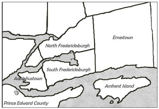
North/South
Division of Fredericksburgh
When Municipal Governments were formed, many
townships had no halls or places of their own in which to hold council
or public meetings and taverns were used for
this purpose.
Meetings alternated between the North and
South parts of Fredericksburgh Township.
In the northern part of the township meetings
were held at the Lucas Tavern, known as the
Dew Drop Inn north of Big Creek Bridge on
Country Road #8.
In the southern part of the Township,
meetings were held at Charters' Tavern in the community of Sillsville.
Both buildings still stand as residential
homes.
Most people in the southern part of the
Township traveled east to Bath for their supplies
whereas those living north of Big Creek
shopped in Napanee.
As a result there was no great urgency by
either the south or the north to properly maintain a connecting road.
This condition remained until the time of the
county road system.
There was an on-going dispute as to where to
hold council meetings and the tension increased
when a site for a permanent township building
was discussed.
Thus it seemed reasonable at the time to
solve the problem by separating into a North and South Township.
This occurred in 1857.
|
South Fredericksburgh
Click map for larger view |
North Fredericksburgh
Click map for larger view |

The Township of Adolphustown
“Fourth Town of Cataraqui”
Click map for larger view
Named for Adolphus,
Duke of Cambridge,
tenth son of George III
First Loyalists arrived June 16, 1784.
11,500 acres

|
|
|
|
|
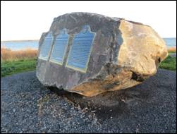
The AFHS celebrated the 240th anniversary of
the founding of the townships of Adolphustown & Fredericksburgh
|
||
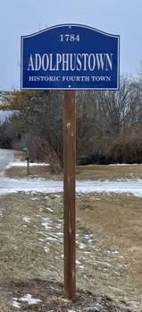


Adolphustown
Township
|
Originally
“Fourth Town,” settled by the U.E.L who landed June 16 1784. With 1998
Amalgamation it became part of the Town of Greater Napanee. |
|
Adolphustown Village
Adolphustown Township (South) |
Originally
called “Hollandsville”. John A. Macdonald attended the early village
school. Although an exact date is not known, a post office was opened here ca1821 under James Watson. The village consisted of
stores, a hotel, the town hall, a mill, a church, at least two cemeteries and
numerous homes. |
Anderson
North Fredericksburgh Township |
Little
Creek Road West at County Road #9. Anderson Methodist/United Church was built
on land donated by Thomas Anderson, and the area was commonly called
“Anderson.” |
Bardolph
Adolphustown Township (North) |
Located
along the northern stretch of County Road #9. [Concession 5] The first post
office was opened in May 1882 by H.B. Seeley. |
|
Bay Centre
North Fredericksburgh Township |
Located
along the southern stretch of County Road #9. A post office was opened here
in 1909. |
Bethany
North Fredericksburgh Township |
Located
along the northern stretch of County Road #9. Once the site of a one-room
school and a Methodist Church. The Church Cemetery is still active today. |
|
Big Creek
North Fredericksburgh Township |
Located on
Big Creek Road. Once the site of a one-room school (now a private residence.)
Close’s Mills/Chambers is located on the east end. |
Chambers/Close’s Mills
North Fredericksburgh Township |
Located
just off Big Creek Road. The first Lutheran church in Ontario was built here
in 1803. The cemetery remains. The post office was opened under William J.
Chambers in 1879. |
|
|
Clapham Fredericksburgh Township |
Records
show a post office opened in 1851 under Edward D. Lalanne
and closed in 1854 when John Clapp was postmaster. Exact location has not yet
been discovered. |
Clappville
Adolphustown and/or
Fredericksburgh
Township
(South)
|
In 1844, a
number of inhabitants of both Adolphustown and Fredericksburgh met at Robert Leach’s
Inn to name the village in the 3rd Concession. It was agreed that
the village be “known as the name of Clappville”.
No further references to the name have been found. |
|
Clarksville
North Fredericksburgh Township |
A
settlement on the south side of the Napanee River, Concession 7, established
about 1785, when Robert Clark was commissioned to build a mill at the Napanee
falls. |
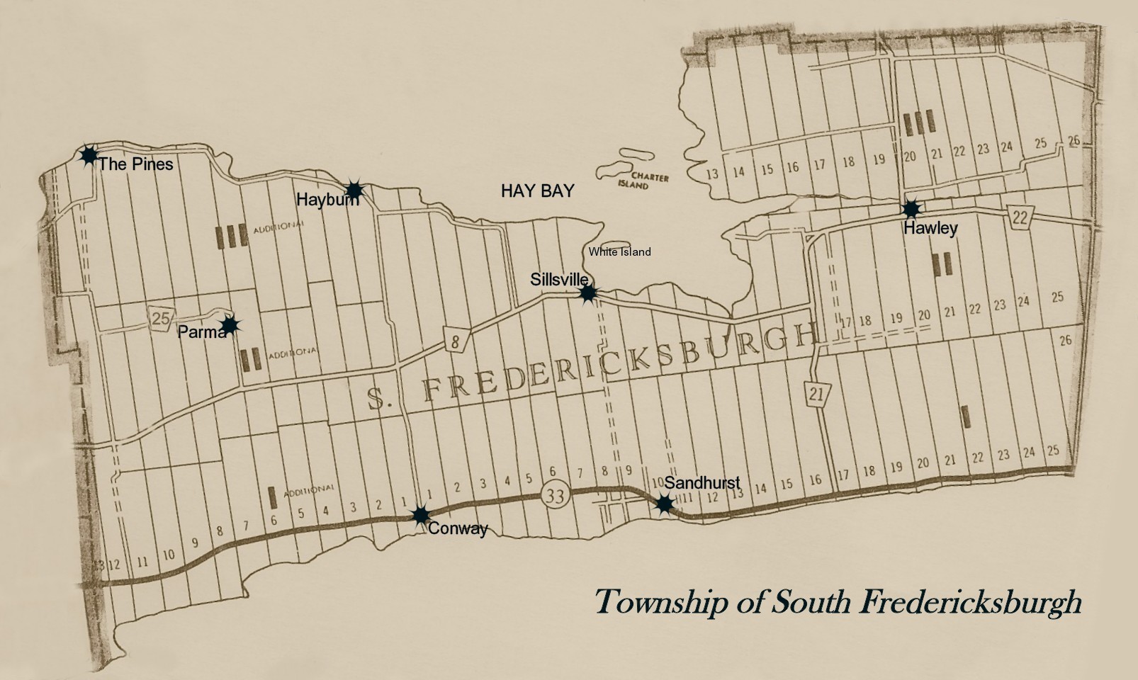
Conway
South Fredericksburgh Township |
The “Conway
Post Office” was opened in 1860 under Edward Howard. It was closed in 1914.
Formerly a thriving area, a popular stop for the early steamers, with a dock,
warehouse, elevators, store, a cheese factory and a Methodist [United]
church. The church and store remain active today. |
|
Dorland
Adolphustown Township (South) |
Corner of
County Road #8 and the South Shore of Hay Bay Road. Elias Clapp was the first
postmaster, appointed in 1878. The P.O. closed in 1927. |
Fredericksburgh (Village)
South Fredericksburgh Township |
Originally
laid out as a townsite on the first concession, but
was never developed. The post office was opened at an early date, with
Anderson as P.M. In 1860, the P.O. was moved. Today, the village plot is part
of “Sandhurst”. |
|
|
Fredericksburgh Station North Fredericksburgh Township |
Located at
the eastern end of Big Creek Road. Original site of the Fredericksburgh train
station. |
Fredericksburgh Township |
Originally “Third Town” Divided
into North and South Fredericksburgh in 1859. The “Fredericksburgh Post
Office” was in operation in the 1820s, located on
the first concession. 1998 Amalgamation: part of the town of Greater Napanee. |
|
Glen Island
Adolphustown
Township (south) |
Originally
known as “Hogs’ Island.” Formerly known
as “Davy’s Island.” Located in
the south west section of Bass Cove [Carnahan Bay]. Once a
popular summer resort, with numerous cottages and a post office established
in 1900. Privately
owned today. |
Gosport
Adolphustown Township (North) |
Situated in
the western section of North Adolphustown, along County Road #9. Once the
site of a church and a school. Nicholas Bogart was in charge of the first
post office, opened in 1856. The P.O. closed in 1913. |
|
Gretna
North Fredericksburgh Township |
Located
along the northern stretch of County Road #9. The first post office was
opened by Nelson Woodcock in 1856. It closed in 1914. |
Hamburg
South Fredericksburgh Township |
Also known
as “Ham’s Corners” in the early years. The area later known as “Hawley.” Was
once the site of a one-room school and blacksmith shop. Named after the first
postmaster, Richard Ham, appointed in 1851. The road going south out of
Napanee (County Road #8) is known locally as the “Hamburg Road”. |
|
Hawley
South Fredericksburgh Township |
The
area along County Road #22. Hawley Methodist [United] Church is still
standing and is privately owned. Named
after the Hawley family. The Hamburg Post Office was renamed Hawley in 1876. |
Hay Bay (north shore)
North Fredericksburgh Township |
Generally
known as the area along the southern stretch of County Road #9, at the
dividing line between North Fredericksburgh original & additional. A post
office opened here with Nicholas Woodcock as Postmaster in 1875. The post
office closed in 1914. |
|
Hayburn
South Fredericksburgh Township |
Located at
the northern end of Township Road #1 on the South Shore Road along Hay Bay.
Once the site of a post office, established in 1886, a Methodist Church (now
demolished) and a one-room school (now a private residence.) The Hay Bay
Ferry docked here and ran across Hay Bay to North Fredericksburgh. |
Hollandsville
Adolphustown Township (South) |
Original
name of the village of Adolphustown, named after Surveyor-General Major
Samuel Holland. The name
was still being used in 1816 in the local papers. |
|
Lenox/Lennox
Fredericksburgh Township |
A post
office; in 1865 John C. Lucas was the postmaster. Exact location has not been
confirmed. |
Little Creek
North Fredericksburgh Township |
The
community around “Little Creek.” A post office established in 1909 with
Solomon Baldwin as postmaster. It closed in 1914. |
|
Macdonald
North Fredericksburgh Township |
Named after
Sir John A. Macdonald. Located along the northern stretch of County Road #9
[Concession 5.] The first postmaster was Goodfellow,
appointed in 1883. The post office closed in 1913. |
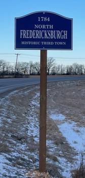
North Fredericksburgh
Township |
Originally
part of “Fredericksburgh Township” [Third Town]. Divided into North and South
in 1858. With 1998 Amalgamation
became part of the town of Greater Napanee. |
|
Parma
South Fredericksburgh Township
|
The area on
the second concession along County Road #8, in the general area of Township
Road #1 and County Road #25. Once the site of a one-room school. A post
office was opened here in 1857 under John C. Green, and closed in 1914. |
Sandhurst
South Fredericksburgh Township |
Located on
Highway #33 [Loyalist Parkway] and situated on the original village plan of
Fredericksburgh. A new “Sandhurst” post office opened in 1869. The old
one-room school and Sandhurst Public School are now both privately owned. St.
Paul’s Anglican Church & Cemetery are still active. McDowall Memorial
Presbyterian Church burned and is now a cemetery site Location of “Sandhurst
Shores” subdivision. |
|
Sillsville
South Fredericksburgh Township |
Previously
site of the South Fredericksburgh Township Hall [demolished], the Sillsville
Cheese Factory [burned] and the Sillsville Methodist/United Church which is
now privately owned. Sillsville
Cemetery is still active. A post
office was opened in 1854 with George E. Sills, postmaster. It operated until
1970. |
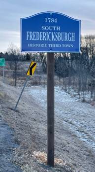
South Fredericksburgh
Township |
Originally
part of “Fredericksburgh Township”[Third Town]. Divided into North and South
in 1858. With 1998
Amalgamation became part of the town of Greater Napanee. |
|
The Pines
South Fredericksburgh Township |
Located on
the South Shore of Hay Bay near the junction of the South Shore Road and County Road #25 [the Gore Road]. Once
the site of a “Union Church”. A post office opened under John Magee in 1893
and continued until 1914. |
U.E. Loyalist
Adolphustown Township (South) |
In 1908,
the “U.E. Loyalist Post Office” opened here with Mark Trumpour as postmaster;
it closed in 1914. It was located on the 3rd Concession Road.
There are no records to indicate that it was actually considered a ‘hamlet.’ |

|
Hwy
33 at the Glenora Ferry, Adolphustown
|
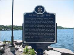
THE ROYAL UNION FLAG 1707-1801 Originally designed in 1606,
this flag was officially adopted in 1707 by England and Scotland as their
royal standard at the time of the union of the thrones and parliaments of
both countries. It consists of the blue background and white diagonal cross
of St. Andrew, Patron Saint of Scotland, with superimposed the red cross of
St. George, Patron Saint of England.
The white piping is a heraldic device used to separate the blue and
red portions. When the American
Revolution began in 1775, many people remained loyal to the British
crown. By the end of the war, most
were compelled to leave the thirteen colonies. About 2000 of a much larger number settled
the townships in and around this area.
They and their descendants are known as United Empire Loyalists. This royal standard was their flag. ERECTED 1998 BY KINGSTON AND
DISTRICT BRANCH OF THE UNITED EMPIRE LOYALISTS’ ASSOCIATION OF CANADA WITH
THE ASSISTANCE OF THE ONTARIO HERITAGE FOUNDATION. |
|
Hwy
33 at the Glenora Ferry, Adolphustown
|
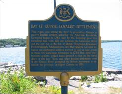
BAY OF QUINTE LOYALIST SETTLEMENT This region was among the first
in present day Ontario to receive loyalist settlers following the American
Revolution. Surveying began in 1783
and by the following year five townships had been laid out between the
Cataraqui River and the east end of the Isle of Quinte (Kingston, Ernestown,
Fredericksburgh, Adolphustown and Marysburgh). Loyalist refugees and discharged soldiers
arrived to take up land grants in these five Cataraqui townships in
1784. That same year Iroquois
loyalists settled lands granted to them on the north shore of this bay. These and other loyalist settlements west
of the Ottawa River prompted the British government to establish the province
of Upper Canada in 1791. Ontario Heritage Foundation, an
agency of the Government of Ontario |
|
UEL
Park, Adolphustown
|
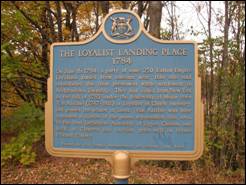
THE LOYALIST LANDING PLACE 1784 On June 16, 1784, a party of some 250 United Empire
Loyalists landed from bateaux near this site and established the first
permanent white settlement in Adolphustown Township. They had sailed from new York in the fall
of 1783 under the leadership of Major Peter Van Alstine
(1747-1811) a Loyalist of Dutch ancestry, and passed the winter at
Sorel. Van Alstine
was later appointed a justice of the peace, represented this area in the
first Legislative Assembly of Upper Canada and built at Glenora the earliest
grist-mill in Prince Edward County. |
|
St.
Alban’s Anglican Church Adolphustown
Village
|
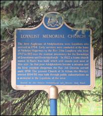
LOYALIST MEMORIAL CHURCH The first Anglicans of
Adolphustown were Loyalists who arrived in 1784. Early services were conducted at the home
of Nicholas Hagerman by the Rev. John Langhorn who, from 1787 to 1813 was the
resident missionary for the Townships of Ernesttown and Fredericksburgh. In
1822 a frame church named St. Paul’s was built, which still stands just west
of this site. In that year
Adolphustown became a mission and its first resident clergyman, the Rev. Job
Deacon, served until 1850. The present
church of St. Alban-the-Martyr, erected 1884-88, was built through public
subscriptions as a memorial to the Loyalists of the area. Erected by the Ontario
Archaeological and Historic Sites Board. |
|
South
Shore Road, north of Dorland, Adolphustown
|
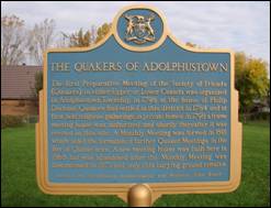
THE QUAKERS OF ADOLPHUSTOWN The first Preparative Meeting
of the Society of Friends (Quakers) in either Upper or Lower Canada was
organized in Adolphustown Township in 1798 at the house of Philip
Dorland. Quakers had settled in this
district in 1784 and at first held religious gatherings in private
homes. In 1798 a frame meeting house
was authorized and shortly thereafter it was erected on this site. A Monthly Meeting was formed in 1801 which
aided the formation of further Quaker Meetings in the Bay of Quinte
area. A new meeting house was built
here in 1868 but was abandoned after the Monthly Meeting was discontinued in
1871 and only this burying ground remains. Erected by the Ontario
Archaeological and Historic Sites Board |
|
South
Shore Road, north-east of Dorland Adolphustown
|
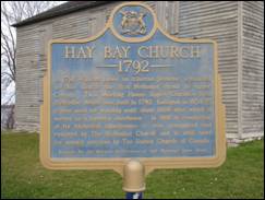
HAY BAY CHURCH 1792 In 1791, William Losee, an itinerant preacher, organized in this
district the first Methodist circuit in Upper Canada. This Meeting House. Upper Canada’s first
Methodist chapel, was built in 1792.
Enlarged in 1834-35 it was used for worship until about 1860 after
which it served as a farmer’s storehouse.
In 1910 in recognition of its historical significance, it was reacquired
and restored by The Methodist Church and is still used for annual services by
The United Church of Canada. Erected by the Ontario
Archaeological and Historic Sites Board |
|
South
Shore Road, just west of the Old Hay Bay Church, Adolphustown
|
SIR JOHN ALEXANDER
MACDONALD 1815-1891 Born in
Scotland, the young Macdonald returned frequently during his formative years to
his parents' home here on the Bay of Quinte. His superb skills kept him at
the centre of public life for fifty years. The political genius of
Confederation, he became Canada's first prime minister in 1867, held that
office for nineteen years (1867-73 and 1878-91), and presided over the
expansion of Canada to its present boundaries excluding Newfoundland. His
National Policy and the building of the CPR were equally indicative of his
determination to resist the north-south pull of geography and to create and
preserve a strong country politically free and commercially autonomous. Note:
Monument is still in place, but plaque has been removed by Parks Canada. |
|
Hwy
33, West of Conway South
Fredericksburgh
|
HAZELTON SPENCER 1757-1813 An important figure in early Upper Canada, Spencer was born in East
Greenwich, Rhode Island. During the American
revolution, he fought with the British forces and in 1784, when his unit was
disbanded, he settled here. Widely
acknowledged as a man of ability and stature, Spencer quickly achieved
prominence. He represented this region
in the province’s first parliament (1792-96) and secured several judicial and administrative
appointments. Continuing his
distinguished military career he was commissioned an officer in the Royal Canadian
Volunteer Regiment and served in the garrison at Kingston (1797-1800) where
he was commandant and at Fort George (1800-02). Spencer gained his highest office in 1794,
however, with his appointment as Lieutenant of the County of Lennox. He held this prestigious post until his
death. |
|
St.
Paul’s Anglican Church Sandhurst,
South Fredericksburgh
|
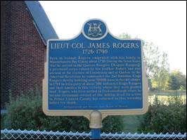
LIEUT.-COL. JAMES ROGERS 1726-1790 Born in Ireland, Rogers
emigrated with his family to Massachusetts Bay colony about 1730. During the Seven Years’ War he served in the
Queen’s Rangers (Rogers’ Rangers), a provincial corps raised by his brother
Robert and was present at the capture of Louisbourg
and of Quebec. In the American
Revolution he commanded the 2nd Battalion Kings Rangers thereby
forfeiting some 50,000 acres in the old colonies. In 1784 he led a party of about 300
disbanded Kings Rangers and their families to this vicinity where they were
granted land. Rogers, who first
settled in Fredericksburgh where he became lieutenant-colonel of the militia,
lived for a time in Prince Edward county but returned to his township before
his death. Archaeological and Historic
Sites Board of Ontario |
|
McDowall
Memorial Cemetery Sandhurst,
South Fredericksburgh
|
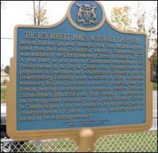
THE REV. ROBERT JAMES McDOWALL 1768-1841 Born at Ballston Spa, near
Saratoga, new York, McDowall graduated from the Union Theological Seminary,
Schenectady, and was ordained by the Dutch Reformed church at Albany in
1797. A year later he was sent to
Canada and ministered to the Presbyterians in the Bay of Quinte area. He organized congregations in Ernesttown
and Adolphustown Townships, and in Fredericksburg Township where he settled in
1800. A zealous missionary, McDowall
travelled extensively preaching and performing marriage ceremonies at
numerous centres between Elizabethtown (Brockville)
and York (Toronto). His efforts as the
first appointed missionary of the Dutch Reformed church in Canada helped to
lay the foundation for the development of Presbyterianism in Ontario. He died at Sandhurst and was buried in the
adjoining cemetery. Erected by the Ontario Heritage
Foundation Ministry of Culture and
Recreation |
|
Hwy
33 West of County Rd 21, South
Fredericksburgh
|
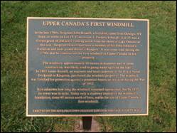
UPPER CANADA'S FIRST WINDMILL In the late 1780s,
Sergeant John Howell, a Loyalist, came from Oswego NY State, to settle on Lot
15, Concession 1, Fredericksburgh. Lot 15 was a Crown grant of 200 acres
running north from the shore of Lake Ontario at this site. Sergeant Howell
had been a member of Sir John Johnson's Battalion and later joined Butler's
Rangers. It was some time during the 1790s that he
constructed the first windmill in Upper Canada on his property. The
windmill, approximately 10 metres in diameter and
of stone construction, was likely used to pump water up from the lake. In
1803 James Russell, an engineer and head carpenter at the Royal Naval
Dockyard in Kingston, purchased the windmill property. The windmill was
fortified for protection against a potential American invasion during the War
of 1812. It is
unknown how long the windmill remained operational, but by 1877 its tower was
in ruins. Today only a shadowy imprint of the windmill's foundation, some 45 metres north of here, marks the site of Upper Canada's
first windmill. ERECTED
BY THE ADOLPHUSTOWN-FREDERICKSBURGH HERITAGE SOCIETY IN 2012 |
|
Hwy
33 at County Rd 21, South
Fredericksburgh
|
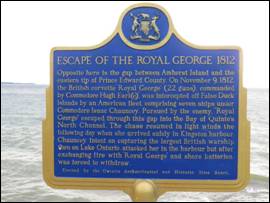
ESCAPE OF THE ROYAL GEORGE 1812 Opposite here is the gap between Amherst Island and the eastern tip of
Prince Edward County. On November 9,
1812, the British corvette “Royal George” (22 guns), commanded by Commodore
Hugh Earl(e), was intercepted off False Duck Islands by an American fleet,
comprising seven ships under commodore Isaac Chauncey. Pursued by the enemy, “Royal George”
escaped through this gap, into the Bay of Quinte’s
North Channel. The chase resumed in
light winds the following day when she arrived safely in Kingston
harbour. Chauncey, intent on capturing
the largest British warship then on lake Ontario, attacked her in the harbour
but after exchanging fire with “Royal George” and shore batteries was forced
to withdraw. Erected by the Ontario Archaeological and Historic Sites Board. |
|
Hwy
33 East of County Rd 21, South
Fredericksburgh
|
Upper Gap Archaeological Site First
Nations peoples lived in this area thousands of years before the arrival of
Europeans. In 1995, archaeological evidence of Iroquoian settlement was
discovered nearby. The artifacts found reflected several periods of
habitation dating from A.D. 700 to A.D 1400 and included the remains of
decorated ceramic pots, vessels for cooking and storage, and stone tools.
Hundreds of years ago, the Iroquois lived in longhouses and practised an
agricultural way of life, cultivating primarily corn, beans and squash. This
site was likely chosen for its strategic location overlooking the open
channel, or Upper Gap between Amherst Island and Cressy Point. It provided
access to Lake Ontario for fishing, hunting, gathering, ceremonial purposes
and for other Aboriginal peoples. Ontario
Heritage Foundation, an agency of the Government of Ontario |