|
Hwy 33 at the Glenora Ferry, Adolphustown
|
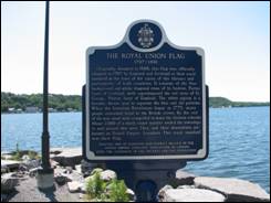
THE
ROYAL UNION FLAG 1707-1801 Originally
designed in 1606, this flag was officially adopted in 1707 by England and Scotland
as their royal standard at the time of the union of the thrones and
parliaments of both countries. It consists of the blue background and white
diagonal cross of St. Andrew, Patron Saint of Scotland, with superimposed the
red cross of St. George, Patron Saint of England. The white piping is a heraldic device used
to separate the blue and red portions.
When the American Revolution began in 1775, many people remained loyal
to the British crown. By the end of
the war, most were compelled to leave the thirteen colonies. About 2000 of a much larger number settled
the townships in and around this area.
They and their descendants are known as United Empire Loyalists. This royal standard was their flag. ERECTED
1998 BY KINGSTON AND DISTRICT BRANCH OF THE UNITED EMPIRE LOYALISTS’
ASSOCIATION OF CANADA WITH THE ASSISTANCE OF THE ONTARIO HERITAGE FOUNDATION. |
|
Hwy 33 at the Glenora Ferry, Adolphustown
|
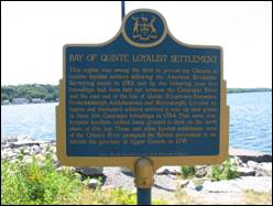
BAY OF
QUINTE LOYALIST SETTLEMENT This
region was among the first in present day Ontario to receive loyalist
settlers following the American Revolution.
Surveying began in 1783 and by the following year five townships had
been laid out between the Cataraqui River and the east end of the Isle of
Quinte (Kingston, Ernestown, Fredericksburgh, Adolphustown and
Marysburgh). Loyalist refugees and
discharged soldiers arrived to take up land grants in these five Cataraqui
townships in 1784. That same year
Iroquois loyalists settled lands granted to them on the north shore of this
bay. These and other loyalist
settlements west of the Ottawa River prompted the British government to
establish the province of Upper Canada in 1791. Ontario
Heritage Foundation, an agency of the Government of Ontario |
|
UEL Park, Adolphustown
|
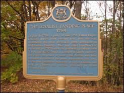
THE
LOYALIST LANDING PLACE 1784 On June 16, 1784, a party of some 250
United Empire Loyalists landed from bateaux near this site and established
the first permanent white settlement in Adolphustown Township. They had sailed from new York in the fall
of 1783 under the leadership of Major Peter Van Alstine
(1747-1811) a Loyalist of Dutch ancestry, and passed the winter at
Sorel. Van Alstine
was later appointed a justice of the peace, represented this area in the
first Legislative Assembly of Upper Canada and built at Glenora the earliest
grist-mill in Prince Edward County. |
|
St. Alban’s Anglican Church Adolphustown Village
|
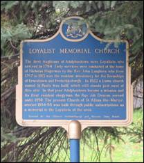
LOYALIST
MEMORIAL CHURCH The
first Anglicans of Adolphustown were Loyalists who arrived in 1784. Early services were conducted at the home
of Nicholas Hagerman by the Rev. John Langhorn who, from 1787 to 1813 was the
resident missionary for the Townships of Ernesttown and Fredericksburgh. In
1822 a frame church named St. Paul’s was built, which still stands just west
of this site. In that year
Adolphustown became a mission and its first resident clergyman, the Rev. Job
Deacon, served until 1850. The present
church of St. Alban-the-Martyr, erected 1884-88, was built through public
subscriptions as a memorial to the Loyalists of the area. Erected
by the Ontario Archaeological and Historic Sites Board. |
|
South Shore Road, north of Dorland, Adolphustown
|
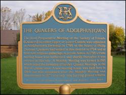
THE
QUAKERS OF ADOLPHUSTOWN The
first Preparative Meeting of the Society of Friends (Quakers) in either Upper
or Lower Canada was organized in Adolphustown Township in 1798 at the house
of Philip Dorland. Quakers had settled
in this district in 1784 and at first held religious gatherings in private
homes. In 1798 a frame meeting house
was authorized and shortly thereafter it was erected on this site. A Monthly Meeting was formed in 1801 which
aided the formation of further Quaker Meetings in the Bay of Quinte
area. A new meeting house was built
here in 1868 but was abandoned after the Monthly Meeting was discontinued in
1871 and only this burying ground remains. Erected
by the Ontario Archaeological and Historic Sites Board |
|
South Shore Road, north-east of Dorland Adolphustown
|
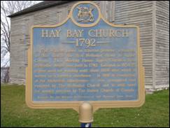
HAY BAY
CHURCH 1792 In 1791, William Losee, an itinerant preacher, organized in this
district the first Methodist circuit in Upper Canada. This Meeting House. Upper Canada’s first
Methodist chapel, was built in 1792. Enlarged in 1834-35 it was used for worship
until about 1860 after which it served as a farmer’s storehouse. In 1910 in recognition of its historical
significance, it was reacquired and restored by The Methodist Church and is
still used for annual services by The United Church of Canada. Erected by the Ontario Archaeological and Historic Sites Board |
|
South Shore Road, just west of the Old Hay Bay
Church, Adolphustown
|
SIR JOHN
ALEXANDER MACDONALD 1815-1891
Born in Scotland, the young Macdonald returned frequently during his formative
years to his parents' home here on the Bay of Quinte. His superb skills kept
him at the centre of public life for fifty years. The political genius of
Confederation, he became Canada's first prime minister in 1867, held that
office for nineteen years (1867-73 and 1878-91), and presided over the
expansion of Canada to its present boundaries excluding Newfoundland. His
National Policy and the building of the CPR were equally indicative of his
determination to resist the north-south pull of geography and to create and
preserve a strong country politically free and commercially autonomous. |
|
Hwy 33, West of Conway South Fredericksburgh
|
HAZELTON
SPENCER 1757-1813 An important figure in early Upper Canada, Spencer was born in East
Greenwich, Rhode Island. During the
American revolution, he fought with the British forces and in 1784, when his
unit was disbanded, he settled here.
Widely acknowledged as a man of ability and stature, Spencer quickly
achieved prominence. He represented
this region in the province’s first parliament (1792-96) and secured several judicial
and administrative appointments.
Continuing his distinguished military career he was commissioned an
officer in the Royal Canadian Volunteer Regiment and served in the garrison
at Kingston (1797-1800) where he was commandant and at Fort George
(1800-02). Spencer gained his highest
office in 1794, however, with his appointment as Lieutenant of the County of
Lennox. He held this prestigious post
until his death. |
|
St. Paul’s Anglican Church Sandhurst, South Fredericksburgh
|
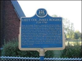
LIEUT.-COL.
JAMES ROGERS 1726-1790 Born
in Ireland, Rogers emigrated with his family to
Massachusetts Bay colony about 1730.
During the Seven Years’ War he served in the Queen’s Rangers (Rogers’
Rangers), a provincial corps raised by his brother
Robert and was present at the capture of Louisbourg
and of Quebec. In the American
Revolution he commanded the 2nd Battalion Kings Rangers thereby
forfeiting some 50,000 acres in the old colonies. In 1784 he led a party of about 300
disbanded Kings Rangers and their families to this vicinity where they were
granted land. Rogers, who first
settled in Fredericksburgh where he became lieutenant-colonel of the militia,
lived for a time in Prince Edward county but returned to his township before
his death. Archaeological
and Historic Sites Board of Ontario |
|
McDowall Memorial Cemetery Sandhurst, South Fredericksburgh
|
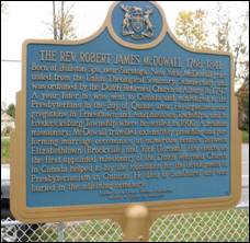
THE
REV. ROBERT JAMES McDOWALL 1768-1841 Born
at Ballston Spa, near Saratoga, new York, McDowall graduated from the Union
Theological Seminary, Schenectady, and was ordained by the Dutch Reformed
church at Albany in 1797. A year later
he was sent to Canada and ministered to the Presbyterians in the Bay of
Quinte area. He organized
congregations in Ernesttown and Adolphustown Townships, and in Fredericksburg
Township where he settled in 1800. A
zealous missionary, McDowall travelled extensively preaching and performing
marriage ceremonies at numerous centres between Elizabethtown (Brockville)
and York (Toronto). His efforts as the
first appointed missionary of the Dutch Reformed church in Canada helped to
lay the foundation for the development of Presbyterianism in Ontario. He died at Sandhurst and was buried in the
adjoining cemetery. Erected
by the Ontario Heritage Foundation Ministry
of Culture and Recreation |
|
Hwy 33 West of County Rd 21, South Fredericksburgh
|
UPPER
CANADA'S FIRST WINDMILL In the late
1780s, Sergeant John Howell, a Loyalist, came from Oswego NY State, to settle
on Lot 15, Concession 1, Fredericksburgh. Lot 15 was
a Crown grant of 200 acres running north from the shore of Lake Ontario at
this site. Sergeant Howell had been a member of Sir John Johnson's Battalion
and later joined Butler's Rangers. It was some time during the 1790s that he
constructed the first windmill in Upper Canada on his property. The windmill, approximately 10 metres in diameter
and of stone construction, was likely used to pump water up from the lake. In
1803 James Russell, an engineer and head carpenter at the Royal Naval
Dockyard in Kingston, purchased the windmill property. The windmill was
fortified for protection against a potential American invasion during the War
of 1812. It is unknown how long the windmill remained
operational, but by 1877 its tower was in ruins. Today only a shadowy imprint
of the windmill's foundation, some 45 metres north of here, marks the site of
Upper Canada's first windmill. ERECTED BY THE ADOLPHUSTOWN-FREDERICKSBURGH
HERITAGE SOCIETY IN 2012 |
|
Hwy 33 at County Rd 21, South Fredericksburgh
|
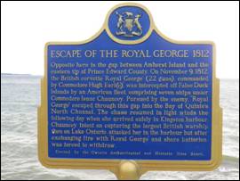
ESCAPE OF
THE ROYAL GEORGE 1812 Opposite here is the gap between Amherst Island and the eastern tip
of Prince Edward County. On November
9, 1812, the British corvette “Royal George” (22 guns), commanded by
Commodore Hugh Earl(e), was intercepted off False Duck Islands by an American
fleet, comprising seven ships under commodore Isaac Chauncey. Pursued by the enemy, “Royal George” escaped
through this gap, into the Bay of Quinte’s North
Channel. The chase resumed in light
winds the following day when she arrived safely in Kingston harbour. Chauncey, intent on capturing the largest
British warship then on lake Ontario, attacked her in the harbour but after
exchanging fire with “Royal George” and shore batteries was forced to
withdraw. Erected by the Ontario Archaeological and Historic Sites Board. |
|
Hwy 33 East of County Rd 21, South Fredericksburgh
|
Upper Gap Archaeological
Site First Nations peoples lived in this area
thousands of years before the arrival of Europeans. In 1995, archaeological
evidence of Iroquoian settlement was discovered nearby. The artifacts found
reflected several periods of habitation dating from A.D. 700 to A.D 1400 and
included the remains of decorated ceramic pots, vessels for cooking and
storage, and stone tools. Hundreds of years ago, the Iroquois lived in
longhouses and practised an agricultural way of life, cultivating primarily corn,
beans and squash. This site was likely chosen for its strategic location
overlooking the open channel, or Upper Gap between Amherst Island and Cressy
Point. It provided access to Lake Ontario for fishing, hunting, gathering, ceremonial purposes and for other Aboriginal peoples. Ontario Heritage Foundation, an agency of
the Government of Ontario |